Severe Weather Dynamics in the Southeast: Tracking the Feb 12th System Across AL/GA/SC
Deciphering the Complexity of Ongoing Storms and Future Convective Activity
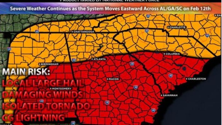
As the Southeast braces for severe weather on February 12th, a complex system unfolds across Alabama (AL), Georgia (GA), and eventually into South Carolina (SC). Ongoing storms in AL and GA add to the intricate nature of the forecast, with convective activity expected to intensify as the system progresses eastward. However, the presence of outflow boundaries complicates the situation, influencing the severity of the weather depending on their positioning. Despite these challenges, vigilance remains crucial to monitor and respond to the evolving threat.
The forecast for the Southeast is shaped by various meteorological factors. A positively tilted trough originating from the ArkLaTex region evolves into a closed cyclone at the mid to upper levels of the atmosphere. Concurrently, robust mid-level flow precedes the system, setting the stage for volatile weather conditions. At the surface, a low-pressure system with a cold front moves eastward, while a warm front attempts to push northward. However, outflow boundaries from ongoing storms hinder the northward progression of the warm front, delaying the influx of warm air crucial for atmospheric instability. This delay temporarily mitigates the immediate severe weather risk.

The severity and timing of the impending severe weather depend on the interplay of atmospheric dynamics. Ongoing storms primarily affect areas north of the warm front, limiting their intensity to localized large hail and damaging winds. As the system advances eastward, the potential for convective activity increases, especially if the warm front moves further north. In such a scenario, a convergence of moist air, instability, and a low-level jet creates conditions conducive to severe weather phenomena, including large hail, damaging winds, and isolated tornadoes. However, uncertainty remains regarding the northward movement of the warm front, underscoring the need for preparedness and vigilance.

The timing and impact of severe weather are linked to the system’s progression and atmospheric conditions. Ongoing storms persist across AL and GA during the morning hours, primarily north of the warm front. While these storms pose a localized threat, the stable air mass below the warm front mitigates overall severity. As the system moves eastward, convective activity intensifies, particularly across GA and into the Carolinas. However, the extent of this activity depends on the northward displacement of the warm front and resulting atmospheric instability. Residents in affected regions must remain vigilant as the system unfolds, with severe weather diminishing by Monday night as the system exits the area.
Read More News:
- Biden Holds a 6-Point Lead Over Trump in Recent Poll: Analyzing Key Factors and Issues
- Colorado Lawmakers Pave the Way for Adult Education Diploma Program
In summary, the forecast for severe weather in the Southeast on February 12th highlights the complexity of meteorological dynamics and the need for preparedness. Ongoing storms and outflow boundaries shape the immediate risk, while the potential for convective activity underscores the importance of monitoring evolving weather conditions. Preparedness and timely response are crucial to mitigating the impact of severe weather events and ensuring the safety of communities across AL, GA, and SC.


