Minor Earthquake Rattles Southern California with 3.8 Magnitude Tremor

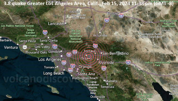
A seismic event with a magnitude of 3.8 shook Southern California, specifically in the vicinity of Ontario, close to San Bernardino County, as reported by the United States Geological Survey (USGS). The quake, which occurred on Thursday night, was situated approximately six miles south of Rancho Cucamonga and around 18 miles southwest of San Bernardino. Notably, its effects reached as far as Los Angeles and Huntington Beach.
Details of the Quake: The earthquake, originating about eight miles beneath the surface, struck at approximately 11:38 p.m. local time on Thursday. Fortunately, there have been no immediate reports of damage or injuries associated with the tremor.
Recent Seismic Activity in Southern California: This seismic event follows a series of nearly 20 earthquakes that recently rattled various parts of Southern California. The initial earthquake, documented on February 11, registered a magnitude of 4.8 and occurred northwest of El Centro, California. Subsequent tremors continued to affect El Centro and Imperial, two cities situated east of San Diego near the Mexico border.
As the region grapples with these seismic occurrences, residents remain vigilant, and experts closely monitor the situation for any potential developments.
HOW DOES EARTHQUAKE OCCUR?
Tectonic Plates Composition and Movement
The Earth’s surface comprises approximately 15 tectonic plates that are in constant motion, interacting in diverse ways. These plates consist of continental and oceanic components, creating a dynamic and ever-changing geological landscape.
Plate Boundaries: Hubs of Geological Activity
The regions where tectonic plates meet are known as plate boundaries. These areas witness intense fracturing, and the plate surfaces are marked by intricate cracks called fault lines. Different interactions occur at plate boundaries, shaping the Earth’s crust in various ways.
Plate Movements and Geological Transformations
Tectonic plates exhibit different movements at plate boundaries. Some plates drift apart, resulting in breakage and cracking. Thinning plates can lead to lava eruptions, forming new oceanic crust through a process known as rifting. In contrast, collisions between plates can cause subduction, where one plate slips beneath another, shaping the Earth’s mantle.
Plate Interactions: Mountain Formation and Sliding Movements
When continental plates, being thicker and more buoyant, collide, they push against each other, forming mountains such as the Himalayas. In other scenarios, plates simply slide past each other at conservative plate boundaries, showcasing the diverse geological consequences of plate interactions.
Also Read : Unnoticed Tremors: Washington State’s Silent Quakes Amidst Impending Catastrophe
Plate Dynamics and Earthquake Generation
Tectonic plates move at an average rate of approximately 4 centimeters per year, akin to the growth rate of fingernails. The immense size and weight of these plates lead to high friction at their boundaries. Over time, this friction builds up, causing slabs of rock separated by fault lines to become stuck. When the pressure is released, earthquakes occur, with their magnitude dependent on fault size and the extent of rock movement.
: Earth’s Most Powerful Quakes at Subduction Plate Boundaries
The most significant earthquakes occur at subduction plate boundaries. The 2004 Sumatra Boxing Day earthquake, triggering a devastating tsunami, exemplifies this. Taking place along a 1,300-kilometer fault line, it reached a magnitude of 9.1, underlining the tremendous geological forces at play in these regions.