From Chilly Beginnings to Mild Interludes and Beyond
As New Englanders prepare to navigate the upcoming week, they’re in for a journey through various weather patterns, ranging from chilly starts to mild interludes, with the potential for precipitation and a return to colder conditions. Here’s a detailed forecast for the week ahead:
Monday & Tuesday: Chilly Start, Tranquil Conditions The week kicks off with an area of low pressure to the north, dragging a cold front across New England. This will maintain a chilly north-westerly flow, keeping temperatures relatively low for the start of the week. Despite the cold, expect mostly sunny skies across much of the region, although eastern Maine may experience more cloud cover due to the departing system.
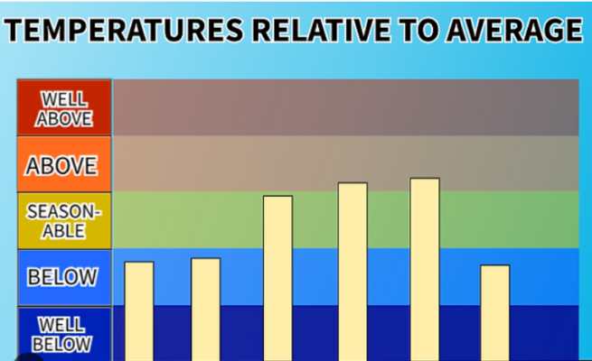
High pressure begins to build in on Monday, setting the stage for quiet and dry weather throughout the week. With high pressure dominating, New Englanders can expect tranquil conditions, with no significant weather events on the horizon. Daytime highs will range from the 20s to 30s, while morning lows will dip into the single digits in some areas, providing a stark reminder of winter’s grasp.
Wednesday & Thursday: Warming Trend Mid-week, a shift in weather patterns brings a welcome change as the polar jet stream retreats northward. This allows for a southerly flow to develop, ushering in milder air from the central United States. As a result, temperatures are expected to climb quickly on Wednesday after a cold start, with highs reaching the 30s in the north and 40s in the south.
The influx of mild air signals a warming trend that will persist through Thursday, with temperatures likely ticking even higher. Mostly sunny to partly cloudy skies are anticipated on Wednesday, providing a pleasant backdrop for the warmer temperatures. However, clouds will begin to increase on Thursday ahead of a storm system approaching from the west.
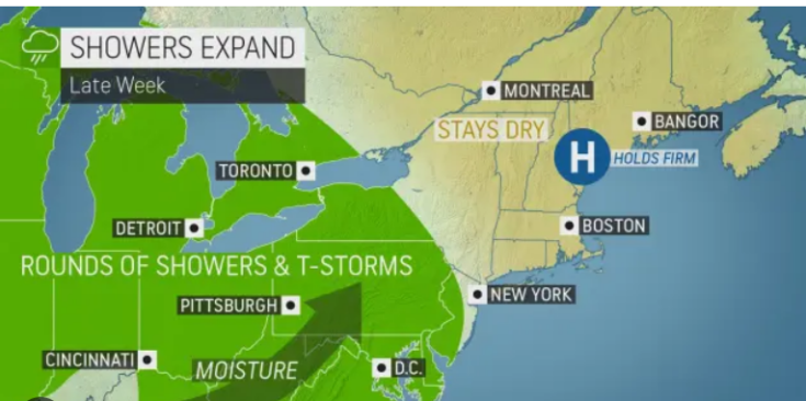
Friday: Potential for Precipitation By Friday, the aforementioned storm system is expected to spread precipitation from west to east across New England. While the system is forecasted to be relatively mild for most areas, there’s a chance of mixing or snow at the onset, particularly in the higher elevations. Southern regions and coastal areas are likely to see mainly rain showers, but details regarding the precipitation type and intensity remain uncertain at this time.

As always, the potential for a surface coastal low to develop adds a layer of complexity to the forecast, which could result in a colder storm and more widespread frozen precipitation. However, indications suggest that the system will be quick-moving without significant impacts, as the northern and southern streams fail to phase.
Weekend Outlook: Return to Colder Conditions Following the passage of the storm system, colder air will once again infiltrate New England, bringing temperatures back below average for the weekend. Highs are expected to drop into the 20s in the north and 30s in the south, accompanied by dry conditions for most areas. However, typical upslope snow showers may occur in the mountains, adding to the wintry ambiance.
Despite the weekend cool down, indications suggest that the post-system cool down will be short-lived, with temperatures rebounding to above-average levels in the long-term pattern. As New Englanders bid farewell to February and welcome the onset of March, a return to milder weather appears imminent, providing a glimmer of hope as winter gradually loosens its grip on the region.
Read More News:
- The Ruthless Incident: A Tale of Dine and Dash Gone Awry
- Nikki Haley Challenges Trump’s Influence on GOP Leadership: Examining the Dynamics of Republican Party Control
The upcoming week in New England promises a rollercoaster of weather transitions, from chilly beginnings to mild interludes, with the potential for precipitation and a brief return to colder conditions. As always, staying informed and prepared for changing weather conditions is essential, ensuring that residents are ready to adapt to whatever Mother Nature has in store.
